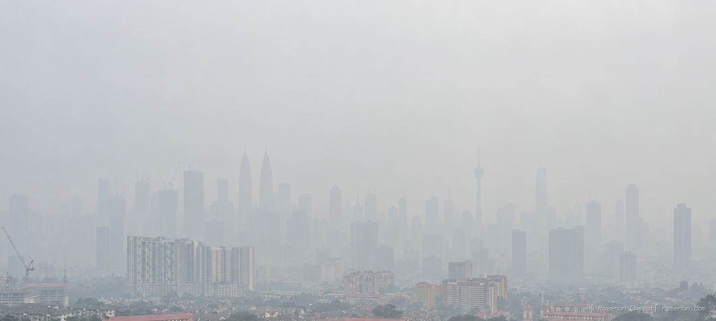
By mid-September, grey skies had returned to parts of Southeast Asia.
In Malaysia, air quality deteriorated rapidly. On September 16, 41 locations across Peninsular Malaysia recorded Air Pollution Index readings in the unhealthy range.
In Kuala Lumpur, Cheras recorded an API of 179 and Batu Muda 172. Across the wider Klang Valley, Shah Alam reached 175, Petaling Jaya 169, Klang 167 and Putrajaya 176. Bernama: 41 areas in Peninsular Malaysia record unhealthy air quality
Further south, Singapore was experiencing the same regional haze episode.
On September 15, the National Environment Agency reported a 24-hour PSI of between 92 and 131, ranging from moderate to unhealthy, while hourly PM2.5 concentrations reached 43–74 micrograms per cubic metre.
The agency said prevailing winds were carrying haze from Kalimantan and Sumatra towards Singapore. NEA Singapore: Haze Situation Update, 15 September 2026
Conditions improved somewhat the following day after rainfall over parts of the region, but Singapore’s authorities continued to warn that haze from southern Sumatra could return if wind conditions again became favourable for transboundary transport. NEA Singapore: Haze Situation Update, 16 September 2026
The haze has also reached farther north.
By September 16, haze originating from wildfires in Sumatra had affected Hat Yai and parts of southern Thailand, where PM2.5 levels rose to around 75–89 micrograms per cubic metre. The Nation Thailand: Sumatra wildfire haze blankets Hat Yai
The main sources of this regional haze lie hundreds of kilometres away, across Sumatra and Kalimantan in Indonesia.
For Southeast Asia, however, this is not a new story.
Indonesia mobilises tens of thousands to fight the wildfires
The scale of Indonesia’s response reflects the severity of the current wildfire season.
On September 9, Indonesia’s National Disaster Mitigation Agency, BNPB, said it had deployed 43,481 ground personnel and 55 aircraft across six priority provinces: Riau, Jambi, South Sumatra, West Kalimantan, Central Kalimantan and South Kalimantan.
By that point, more than 72,000 hectares had already burned across those provinces. ANTARA: BNPB deploys 43,000 personnel and 55 aircraft
Indonesia’s military has also said that 80,026 personnel were either deployed or placed on standby nationwide to support wildfire operations, with additional forces sent to heavily affected areas, particularly West Kalimantan.
Nearly 1,500 personnel were also involved in prevention efforts and community education aimed at discouraging the use of fire for land clearing. Bernama: More than 40,000 personnel deployed for ground firefighting
The response extends far beyond ground crews. More than 50 aircraft have been used for water bombing and weather modification, while Japan has sent three CH-47 Chinook helicopters and support personnel to assist operations in West Kalimantan. AP: Japan joins Indonesia's wildfire firefighting operation
President Prabowo Subianto has also ordered agencies to intensify the response, particularly around wildfire-prone areas near Nusantara, Indonesia’s new capital in East Kalimantan. Bernama: Prabowo orders stronger response as fires spread
The scale of the operation is important.
The current crisis is not simply a case of wildfires burning in Indonesia while neighbouring countries deal with the consequences. Indonesia itself is facing a major environmental and public-health emergency and has committed substantial resources to containing it.
The difficulty is that many of these fires are exceptionally hard to extinguish.
Why peat fires are so difficult to control
A major part of Indonesia’s recurring haze problem is linked to peatlands.
Peat forms over thousands of years as partially decomposed plant material accumulates in waterlogged conditions. In its natural state, peat remains wet and stores enormous amounts of carbon.
But once peatlands are drained for agriculture or other forms of land use, they begin to dry out.
Dry peat is highly combustible.
Unlike a conventional wildfire that moves across vegetation on the surface, peat fires can smoulder underground for long periods, sometimes continuing even after visible flames have disappeared.
Firefighters may extinguish what can be seen above ground while heat remains deep inside the peat layer. The fire can then re-emerge later.
This underground burning is one reason peat fires can generate persistent haze over large areas for days or even weeks.
What is causing the wildfires?
There is no single cause.
Some wildfires begin with the deliberate use of fire to clear land for agriculture. Under ordinary conditions, a small controlled burn may remain contained. But during an exceptionally dry season, fire can spread quickly into surrounding vegetation, forests or peatlands.
It would therefore be inaccurate to describe the wildfires as purely natural.
At the same time, blaming only large corporations would oversimplify the problem.
The broader causes involve land-use practices, agriculture, peatland drainage, weak enforcement in some areas, local burning practices and commercial pressures operating at multiple levels.
The Indonesian government has warned residents, farmers and companies against using fire for land clearing during the current dry conditions because of the high risk that fires may spread beyond control. Reuters: Indonesia's wildfires may last until early November
This year, however, another factor is making the wildfire crisis considerably worse:
El Niño.
El Niño does not start wildfires — but it intensifies the crisis
El Niño does not ignite forests or peatlands.
What it does is create environmental conditions in which wildfires become easier to start, faster to spread and much harder to extinguish.
Reduced rainfall dries vegetation. Higher temperatures remove moisture from the soil. Water levels in peatlands fall.
Land that would normally resist burning can become highly flammable.
The ASEAN Specialised Meteorological Centre, or ASMC, raised the southern ASEAN region to Alert Level 3 on August 26 after detecting numerous hotspots and moderate to dense haze from Kalimantan and Sumatra spreading across national borders. ASMC: Alert Level 3 for the Southern ASEAN Region
El Niño is therefore not the source of the wildfires.
It is a powerful multiplier.
How does haze cross national borders?
The main mechanism is simple:
wind.
Once fine particles and pollutants from wildfires enter the atmosphere, they can travel hundreds or even thousands of kilometres depending on wind direction, wind speed, atmospheric conditions and the altitude at which the haze is transported.
That is how Kuala Lumpur and Singapore can experience poor air quality even though the wildfires themselves are hundreds of kilometres away.
Singapore’s situation on September 15 illustrated the process clearly. Satellite monitoring and regional weather data showed haze from Kalimantan and Sumatra being carried towards the island by prevailing winds. NEA Singapore: Haze Situation Update, 15 September 2026
This is what turns a domestic wildfire emergency into a regional environmental crisis.
A country does not need to have wildfires within its own borders to suffer the consequences.
Indonesians are bearing the heaviest burden
Although the haze has become a regional problem, people living closest to the wildfires in Indonesia are experiencing the most immediate and severe effects.
Indonesia’s Health Ministry reported that by September 9, acute respiratory infections in affected areas had reached 113,336 cases across 63 districts and cities in seven provinces.
Of those, 26,545 cases involved children under the age of five. ANTARA: More than 113,000 respiratory cases linked to wildfire haze
Reuters reported that more than 12.5 million people across seven provinces had been exposed to hazardous haze, while respiratory infections more than doubled within little more than a week. Reuters: Respiratory infections double in a week
The haze has also disrupted air travel in Kalimantan, reduced visibility to below one kilometre in some areas and forced schools to suspend face-to-face classes. AP: Thick haze disrupts flights and schools in Indonesia
This is why the haze crisis cannot be reduced to images of grey skylines or city landmarks disappearing behind polluted air.
It is simultaneously a public-health crisis, an environmental emergency, an economic disruption and an education problem.
ASEAN has been here before — many times
The sight of Kuala Lumpur or Singapore covered in haze is not unique to 2026.
One of Southeast Asia’s worst haze episodes occurred in 1997–1998, when a powerful El Niño coincided with extensive wildfires and land fires in Indonesia.
The resulting transboundary haze affected large parts of the region.
The problem returned repeatedly in subsequent years.
The 2015 haze crisis was particularly severe. Extensive peatland fires generated prolonged haze over Indonesia, Malaysia and Singapore, affecting millions of people.
The World Bank estimated that the 2015 fires cost Indonesia alone around US$16.1 billion, equivalent to roughly 1.9% of the country’s GDP at the time.
The crisis unfolding in 2026 is therefore not an unfamiliar disaster.
It is the return of a problem Southeast Asia has spent decades trying to solve.
Which raises an obvious question:
Why does it keep happening?
ASEAN has had a transboundary haze agreement since 2002
After the devastating 1997–1998 crisis, ASEAN governments began developing a formal regional response.
On June 10, 2002, member states signed the ASEAN Agreement on Transboundary Haze Pollution, or AATHP, in Kuala Lumpur.
The agreement was designed to strengthen cooperation in wildfire prevention, hotspot monitoring, information sharing, emergency preparedness and cross-border assistance during haze episodes.
It entered into force in 2003, and all ASEAN member states have since ratified it, with Indonesia completing ratification in 2014. ASEAN Haze Portal: ASEAN Agreement on Transboundary Haze Pollution
ASEAN has since built satellite-based hotspot monitoring systems, haze forecasting tools and regional early-warning mechanisms that are far more sophisticated than those available during the 1997 crisis.
So it would be inaccurate to say that ASEAN has done nothing.
The problem is that detecting haze is easier than preventing the wildfires and land fires that cause it.
Land management, agricultural practices, peatland drainage, enforcement and commercial interests remain largely domestic responsibilities.
The atmosphere is regional.
That is the central contradiction of Southeast Asia’s haze problem:
the source can be national, but the consequences are regional.
When will the haze end?
No one can say with certainty.
Indonesia’s forestry minister warned on September 16 that the current wildfire season could continue until early November, particularly if the rainy season arrives later than expected.
The government has described 2026 as Indonesia’s most severe wildfire season in 11 years. Reuters: Indonesia's wildfires may last until early November
Much will depend on three factors: the number of new wildfires, prevailing winds and the return of sustained rainfall.
Air quality can improve rapidly after rain or a change in wind direction.
But as long as peatlands remain dry and wildfires continue to burn, transboundary haze can return just as quickly.
After the crises of 1997, 2015 and numerous episodes in between, 2026 is once again confronting Southeast Asia with the same lesson.
The wildfires may begin in one country.
The haze does not remain there.
Indonesia’s mobilisation of more than 43,000 ground personnel, dozens of aircraft and international assistance is essential to containing the immediate emergency.
But the larger challenge is to break a cycle in which the region returns to the same crisis whenever an extreme dry season arrives.
Because in Southeast Asia, wildfires may have coordinates. Haze has no borders.